
Each May marks the anniversary of Colorado’s largest landslide, which occurred on May 25, 2014 in Mesa County. Two successive landslides displaced millions of cubic meters of rock and flowed at an average of 45 miles per hour. The resulting slide is 2.8 miles long. The landslide took the lives of three local men who were investigating damage from the initial landslide to an irrigation canal.
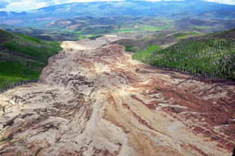
The West Salt Creek Landslide (WSCL) was triggered by unseasonably heavy rain that saturated the ground on the north slope of the Grand Mesa. The event actually included two distinct landslides. The first occurred a little after 7am on the morning of May 25. The initial landslide was smaller and took place overtop a prehistoric landslide site. The second record-setting landslide occurred in the evening around 5:45pm. Nearby residents describe the landslide sounding like a low-flying helicopter or freight train approaching. The landslide caused a magnitude 2.8 earthquake that lasted about 3 minutes and reached the “rock avalanche” stage, meaning that the rock and debris flowed rapidly down a steep slope. It buried three local men under 123 feet of landslide debris. The Colorado Geologic Survey published a report detailing their investigation of the WSCL and guidelines for future land use in the area. A less technical report of the landslide investigation can be found on the U.S. Geologic Survey website.
The WSCL area is characterized by layers of soft sandstone and steep slopes, which creates conditions that lead to frequent landslides. The Grand Mesa saw many landslides before 2014; geologists have found evidence of nearly 800 throughout history that were significant enough to fracture bedrock. A report ranking potential landslide hazards in Colorado notes that geologic features like steep cliffs, bowls, and depressions in the Grand Mesa landscape reveal past landslide activity and the potential for more in the future.
As a mountainous state, Colorado is home to many places like the Grand Mesa that are prone to landslides and rockfall. A team made up of representatives across the state government created the Planning for Hazards website as a guide to prepare for a variety of geologic hazards and prevent loss of life and property. The guide includes a planning framework and multiple information resources for community leaders to aid in developing appropriate land use strategies and prevent building in high-risk areas.

- Impact of wildfire smoke on Colorado’s air quality - June 12, 2026
- Colorado State Parks: Staunton - May 29, 2026
- West Salt Creek Landslide - May 15, 2026