
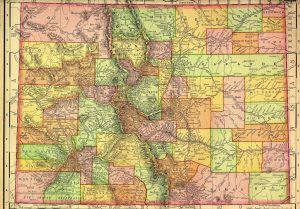
The Colorado State Archives features a website of historical maps of Colorado and the U.S. Here you can view an 1895 map of Colorado, historic maps of Colorado cities and towns, and much more. Also on this site you can find a 1795 map of the “Interior Parts of North America,” an 1855 map of the boundary between the U.S. and Mexico, and maps of discovery, state admissions, and territorial acquisitions. There are also several maps of transportation routes, including stage routes, railroad maps, and stops on the Overland Trail. This is a fascinating website for learning about what Colorado and the West looked like over a century ago.

Former Technical Services Librarian at State Publications Library
Latest posts by Amy Zimmer (see all)
- How to Spot the Differences Between Eagles and Hawks - August 16, 2021
- How Transportation Projects Help Tell the Story of Colorado’s Past - August 9, 2021
- Time Machine Tuesday: The Night the Castlewood Canyon Dam Gave Way - August 3, 2021