
Our series exploring Colorado’s state parks continues with Stagecoach! Stagecoach State Park features a large reservoir for year-round water activities and views of the Flat Tops mountain range.
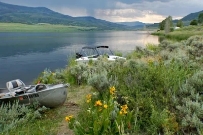
Stagecoach is located 16 miles southwest of Steamboat Springs in northern Colorado. It was developed around Stagecoach Reservoir, a three-mile-long lake that was created along the Upper Yampa River. The reservoir hosts most of the recreational activities in the park. Waterskiing, paddleboarding, and swimming are all popular activities during the summer months. Ice fishing and fat tire biking on the frozen lake are options for the winter and gear can be rented from the park office. Anglers year-round can catch a variety of trout and northern pike – park officials are currently encouraging people to harvest any large pike caught in order to maintain the smaller trout population. A Colorado Outdoors video showcases the recreational activities available at Stagecoach during each of the four seasons.
The reservoir was formed by the Stagecoach Dam, which was constructed by the Upper Yampa Water Conservancy District in 1988. It is intended to serve as a reliable source of water for agricultural and industrial use, as well as creating enough hydroelectric power for about 100 homes in the Yampa Valley each year. The dam was the tenth dam in North America to be constructed using a method called Roller Compacted Concrete and was built in only 37 days. After the construction of the dam, the Water Conservation Board published an interesting report investigating the potential flooding that could occur should the dam fail. While the information luckily hasn’t been needed, the report contains a wealth of information about the construction of the dam and the reservoir.
Colorado has multiple water conservancy districts that manage and protect water resources around the state. The districts are often organized around river basins, like the Upper Yampa River basin. The Yampa River basin extends past state borders, but within Colorado it is approximately 7,660 square miles in size and ranges in elevation from 12,200 feet at the headwaters near the town of Yampa to 5,600 feet near Dinosaur National Monument. Management priorities for the basin include storing water for irrigation and maintaining healthy river flow levels. Extensive information about the Yampa River basin and its management strategy can be found in a 2016 report available in our digital repository.

- Impact of wildfire smoke on Colorado’s air quality - June 12, 2026
- Colorado State Parks: Staunton - May 29, 2026
- West Salt Creek Landslide - May 15, 2026