
Our series travelling Colorado’s Scenic and Historic Byways continues on the Highway of Legends! The epically-named Scenic Highway of Legends Byway traverses a stunning geological landscape that has served as the backdrop to stories of explorers, vengeful gods, and Arapaho heroes for more than 12,000 years.
Highway of Legends is a scenic diversion from I-25 and can be entered in Walsenburg, Trinidad, Aguilar, or La Veta. The 82-mile route is mostly paved and includes an option for a 35-mile extension through the San Isabel National Forest and over the 11,248-foot Cordova Pass. Highway of Legends was recognized by Colorado State Congressional Resolution for its significance two years before the origination of the state byways program, and was officially designated as one of Colorado’s first Scenic and Historic Byways in 1989. It is nationally recognized as a National Forest Scenic Byway and as one of America’s Byways. In 2020, the Colorado Department of Transportation (CDOT) adopted a new corridor management plan that will guide Highway of Legends’ development going forward.
The landscape across Highway of Legends showcases the unique geologic features of south-central Colorado. The Spanish Peaks, two distinctive mountains isolated from the rest of the Sangre de Cristo Mountain range, are the remnants of a 20-million-year-old volcano. Dikes made of hard igneous rocks, evidence of further volcanic activity, radiate out from the two peaks. The most famous of these formations are Devils’ Stairsteps and Profile Rock; in the latter, people claim to see the profiles of George or Martha Washington in the outline of the rock. The nearby Fisher’s Peak (one of Colorado’s newest state parks!) features rock ledges that were formed by more recent lava flows, around 7 million years ago.
This dramatic landscape has inspired equally dramatic stories. Many of the area’s legends relate to stories of lost Aztec gold in the Spanish Peaks, which vengeful gods went to great lengths to protect. The Spanish explorers of the Coronado expedition in 1540 didn’t heed these cautionary tales and supposedly managed to extract a large quantity of gold from the mountains. However, he and his followers disappeared while trying to take their hoard back to Mexico – perhaps the Aztec gods’ delayed revenge? Find the sites of more epic stories using the Scenic Highway of Legends map and read about them in Spanish Peaks: land and legends, available to check out from our library.
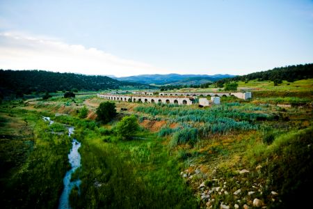
By the late 1800s, Hispanic and Anglo settlers had created permanent communities in the area and southern Colorado was the largest coal-producing region in the state. Abandoned infrastructure from the mining industry can be seen along Highway of Legends, like the ovens preserved in the Cokedale Historic District that were used to convert coal into coke, a type of fuel used in steelmaking. The double lines of arched ovens are a striking site that are said to look more like old Roman ruins than remnants of Colorado’s mining past. To learn more about what life would have been like in company towns like Cokedale, check out Coal people: life in southern Colorado’s company towns, 1890-1930 from our library.

- Impact of wildfire smoke on Colorado’s air quality - June 12, 2026
- Colorado State Parks: Staunton - May 29, 2026
- West Salt Creek Landslide - May 15, 2026