
Our series traveling Colorado’s Scenic and Historic Byways continues along the award-winning Los Caminos Antiguos! Los Caminos Antiguos winds through the remote San Luis Valley, showcasing a high desert landscape flanked by the San Juan and Sangre de Cristo mountain ranges.
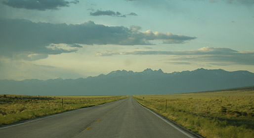
Los Caminos Antiguos Scenic and Historic Byway takes a circuitous 129-mile route from Alamosa to the Colorado-New Mexico border. The route was recognized as a Colorado byway in 1991 and is also designated as a Back Country Byway by the Bureau of Land Management. The Byway’s intentional development is outlined in its 1999 partnership plan to provide interpretation of the state’s history as well as access to natural areas like Zapata Falls and Great Sand Dunes National Park. Los Caminos Antiguos won the National Scenic Byway Foundation’s 2021 Beautification Community Award after the completion of a wetlands preservation project and won the Foundation’s 2023 Interpretation Award.
Los Caminos Antiguos translates to “ancient roads,” and it certainly lives up to its name. Human habitation in the valley goes back 11,000 years and it is now home to a unique blend of indigenous, Hispano, and Anglo cultures. The Spanish arrived in the area during their expeditions in the late 1500s, interacting sporadically with the Ute people through the 1700s. Hispano and Anglo settlers began moving to the valley in the 1850s after it was ceded to the United States following the Mexican-American War. The infrastructure built by these settlers still exists in many places along the Byway, providing direct access to Colorado’s living history:
- San Luis, Colorado’s oldest continually inhabited town, was established in 1851 is also home to the state’s longest-running business, R&R Market.
- The People’s Ditch is Colorado’s oldest water right and flows through San Luis. The ditch was dug in 1851 and is part of the valley’s acequia system (community-operated canals that irrigate agricultural land).
- The oldest Hispano Civil Rights union, La Sociedad Protección Mutua de Trabajadores Unidos, was established in Antonito in 1900 in response to property disputes during the development of the railroad.
More details about the area’s fascinating history can be found in the Byway’s most recent Corridor Management Plan.
Thousands of years of human habitation in the San Luis Valley, along with a variety of wildlife, wetlands, and riparian areas, have been supported by the Rio Grande, which starts in the San Juan Mountains before flowing down to Mexico. The Rio Grande is a critical water source for the arid high desert environment, so water use is governed by the Rio Grande Compact. This interstate agreement was signed in 1938 to ensure that each state in the Rio Grande Basin – Colorado, New Mexico, and Texas – receives a fair portion of water. Between the 1930s-1960s, Colorado failed to adhere to this agreement, often releasing less water than required at the Colorado-New Mexico border. Colorado eventually accumulated a water debt of 1,000,000 acre feet to New Mexico, leading to a lawsuit between the states in 1966. References to conflict can be found in the Rio Grande Compact annual reports from the 1960s, which can be read online through our digital collection.

- Colorado’s Scenic and Historic Byways: Mount Blue Sky - July 15, 2026
- Impact of wildfire smoke on Colorado’s air quality - June 12, 2026
- Colorado State Parks: Staunton - May 29, 2026